15 May 2025
East Star Resources Plc
("East Star" or the "Company")
Talovskoye IP Survey Results
Another priority 2025 drill target demonstrating strong geophysical anomalies
Drill rig expected to mobilise to Talovskoye & Rulikha in two weeks
Further to the 24 April and 13 May 2025 announcements, East Star Resources Plc (LSE:EST), which is exploring for copper and gold in Kazakhstan, is pleased to announce the results of the induced polarisation ("IP") survey from the Talovskoye high priority drill target area in East Kazakhstan.
This target area contains two distinct IP anomalies:
1. (Western Target) A large, deep, high chargeability anomaly reaching amplitudes of up to 45mV/V. This anomaly is approximately 400 x 400m in size, located approximately 100m below surface, and is open at depth
2. (Eastern Target) A small, narrow, near surface, high chargeability anomaly associated with the historic Talovskoye Deposit. This response is open to the north and shows potential to be associated with high-grade pipes, similar to those mined in the past. The flanks and surface of the anomaly contained historical drill results into unmined areas including:
· DH_5: 8.1m @ 1.0% Cu, 0.5% Pb and 0.5% Zn from 28.7m and 5.9m @ 0.6% Cu and 3% Zn from 48.8m
· DH_6: 13m @ 0.75% Cu, 0.5% Pb and 0.1% Zn from surface
· DH_7: 4.3m @ 2.0% Cu, 0.2% Pb and 1.0% Zn from 52.9m
East Star has begun drilling preparation with the rig expected to mobilise to the Rulikha and Talovskoye targets in the next two weeks.
Alex Walker, East Star CEO, commented:
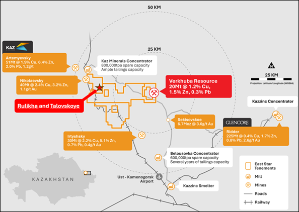
"The Talovskoye target area is hosted within the Talovskaya suite, which is the same geological unit that hosts the high-grade Irtyshsky mine (30Mt @ 2.2% Cu, 5.1% Zn 0.7% Pb and 0.4 g/t Ag) 39km to the southeast, along the Irtysh shear zone. The Eastern Target sits within the boundaries of the historic mining operations and has mineralisation consistently reported in drill results along the flanks and at the surface of the anomaly. The larger Western Target anomaly shows both scale and shape, consistent with regional VMS deposits with potential for a large depth extent. We look forward to drilling the high impact Talovskoye and Rulikha targets in the coming weeks."
|
|
| Figure 1 IP Survey over Talovskoye (110m depth slice) and the untested Western Target (250m depth slice) |

Next Steps
The East Star geological team will be on site within a week to site drill collar locations and confirm access routes and logistics for both Talovskoye and Rulikha.
The drill rig used in the Verkhuba Deposit drill programme in December 2024 is currently located at the Verkhuba site. The drilling contractor has been notified that East Star intends to drill the Rulikha and Talovskoye target areas prior to recommencing work at Verkhuba. Mobilisation of the drill rig is expected to commence in the next two weeks, with drilling to commence shortly after.
Survey Details
The Talovskoye IP Survey was conducted as a 100m pole-dipole in an east-west and then southwest to northeast line direction on 200m line spacing and a 1,300m line length at a frequency of 0.125Hz. Measurements were carried out in a profile-based configuration using a three-electrode forward and reverse setup (AMN-MNA), with simultaneous recording on 32 channels and electrode spacing of 100 m.
Smart Geophysics from Kazakhstan conducted the survey using GDD GRx8-32 receivers and the GDD Tx4 transmitter. Quality control and interpretation were conducted by Mitre Geophysics Pty Ltd, based in Australia.
East Star Resources Plc
Alex Walker, Chief Executive Officer
Tel: +44 (0)20 7390 0234 (via Vigo Consulting)
SI Capital (Corporate Broker)
Nick Emerson
Tel: +44 (0)1483 413 500
Vigo Consulting (Investor Relations)
Ben Simons / Peter Jacob
Tel: +44 (0)20 7390 0234
About East Star Resources Plc
East Star Resources is focused on the discovery and development of copper and gold in Kazakhstan. East Star's management are based permanently on the ground, supported by local expertise. The Company is pursuing three exploration strategies:
· A Volcanogenic Massive Sulphide (VMS) discovery with a maiden JORC MRE of 20.3Mt @ 1.16% copper, 1.54% zinc and 0.27% lead, in an infrastructure-rich region, amenable to a low capex development
· Copper porphyry and epithermal gold exploration, with multiple opportunities for Tier 1 deposits, initially supported by an initial US$500k grant from BHP Xplor in 2024.
· Sediment-hosted copper exploration with Getech where the initial targeting strategy is at no cost to East Star.
Visit our website:
Follow us on social media:
LinkedIn: https://www.linkedin.com/company/east-star-resources/
X (formerly Twitter): https://twitter.com/EastStar_PLC
Subscribe to our email alert service to be notified whenever East Star releases news:
www.eaststarplc.com/newsalerts
The person who arranged for the release of this announcement was Alex Walker, CEO of the Company.
This announcement contains inside information for the purposes of Article 7 of Regulation 2014/596/EU which is part of domestic UK law pursuant to the Market Abuse (Amendment) (EU Exit) Regulations (SI 2019/310) ("UK MAR"). Upon the publication of this announcement, this inside information (as defined in UK MAR) is now considered to be in the public domain.
Competent Person Statement
Scientific or technical information in this disclosure related to exploration was reviewed by Dr Tremain Woods, a full-time employee of Discovery Ventures Kazakhstan Ltd, a 100% owned subsidiary of East Star Resources PLC. Dr Woods is a member in good standing with the Geological Society of South Africa. He has sufficient experience that is relevant to the commodity, style of mineralisation or type of deposit under consideration and activity which he is undertaking to qualify as a Competent Person under the JORC code (2012 Edition).
Table 2 - JORC Code, 2012 Edition
Section 1 Sampling Techniques and Data
| Criteria | JORC Code explanation | Commentary |
| Sampling techniques | · Nature and quality of sampling (e.g. cut channels, random chips, or specific specialised industry standard measurement tools appropriate to the minerals under investigation, such as down hole gamma sondes, or handheld XRF instruments, etc). These examples should not be taken as limiting the broad meaning of sampling. · Include reference to measures taken to ensure sample representivity and the appropriate calibration of any measurement tools or systems used. · Aspects of the determination of mineralisation that are Material to the Public Report. · In cases where 'industry standard' work has been done this would be relatively simple (e.g. 'reverse circulation drilling was used to obtain 1 m samples from which 3 kg was pulverised to produce a 30 g charge for fire assay'). In other cases, more explanation may be required, such as where there is coarse gold that has inherent sampling problems. Unusual commodities or mineralisation types (e.g. submarine nodules) may warrant disclosure of detailed information. | · Samples were taken from diamond drill core through sulphide or oxide mineralised intervals. · Sampling intervals ranged from 0.1 m to over 1.0m · Sample quality was ensured by a GKZ standard calculations to ensure results from X-ray spectral analyses were representative · Core samples were prepared by the geological expeditions by cutting the core in half, crushing and milling the samples (the size fractions aren't recorded but noted as standard fractions), then analysed with X-ray spectral techniques · No core is available for verification sampling
|
| Drilling techniques | · Drill type (e.g. core, reverse circulation, open-hole hammer, rotary air blast, auger, Bangka, sonic, etc) and details (e.g. core diameter, triple or standard tube, depth of diamond tails, face-sampling bit or other type, whether core is oriented and if so, by what method, etc). | · Drilling was conducted using standard NQ sized diamond drilling technique · Various drilling campaigns were conducted by geological expeditions as detailed above · The drill holes purpose ranged from geochemical sampling using KGK techniques (these holes are not included in the data for this announcement) to deeper stratigraphic holes. Only selected holes with assay data through the Talovskoye deposit were included in this announcement · It's unclear if the core was orientated |
| Drill sample recovery | · Method of recording and assessing core and chip sample recoveries and results assessed. · Measures taken to maximise sample recovery and ensure representative nature of the samples. · Whether a relationship exists between sample recovery and grade and whether sample bias may have occurred due to preferential loss/gain of fine/coarse material. | · Core recovery was an average of 42%, the total range was from 17 - 66% recovery · Recovery logs are unavailable for drill hole data base, so the relationship between recovery and grade has not been evaluated. |
| Logging | · Whether core and chip samples have been geologically and geotechnically logged to a level of detail to support appropriate Mineral Resource estimation, mining studies and metallurgical studies. · Whether logging is qualitative or quantitative in nature. Core (or costean, channel, etc) photography. · The total length and percentage of the relevant intersections logged. | · Geologists from the various companies and expeditions completed logging · The logging was approved by the committee for geology · Sections and plan maps were available to verify geology and structure · East Star geologists were able to confirm the geology at surface with geological mapping at a scale of 1:2000 in 2024 · No details of geotechnical logging were captured in the reports |
| Sub-sampling techniques and sample preparation | · If core, whether cut or sawn and whether quarter, half or all core taken. · If non-core, whether riffled, tube sampled, rotary split, etc and whether sampled wet or dry. · For all sample types, the nature, quality, and appropriateness of the sample preparation technique. · Quality control procedures adopted for all sub-sampling stages to maximise representivity of samples. · Measures taken to ensure that the sampling is representative of the in-situ material collected, including for instance results for field duplicate/second-half sampling. · Whether sample sizes are appropriate to the grain size of the material being sampled. | · Half core samples were collected for processing · Sub sampling techniques aren't clearly recorded in the reports available |
| Quality of assay data and laboratory tests | · The nature, quality and appropriateness of the assaying and laboratory procedures used and whether the technique is considered partial or total. · For geophysical tools, spectrometers, handheld XRF instruments, etc, the parameters used in determining the analysis including instrument make and model, reading times, calibrations factors applied and their derivation, etc. · Nature of quality control procedures adopted (e.g. standards, blanks, duplicates, external laboratory checks) and whether acceptable levels of accuracy (i.e. lack of bias) and precision have been established. | · The samples were analyzed using X-ray spectral analysis, which requires finely powdered, homogeneous samples to ensure accurate detection of elements (Cu, Pb, Zn, Au and Ag). · It's unclear if Au and Ag analyses were conducted on all samples analysed · The preparation was tailored to produce a sample compatible with the X-ray spectrometer, typically involving pressing the powdered sample into a pellet or fusing it into a glass bead for analysis, though the reports do not specify these steps · X-ray spectral techniques were commonly used in historical exploration in the soviet era. The techniques have been subsequently replaced by modern analytical techniques. However, they are generally viewed as having produced accurate results. The quality of the data has only been evaluated as reported historically by East Star geologists and have been represented as such in this announcement |
| Verification of sampling and assaying | · The verification of significant intersections by either independent or alternative company personnel. · The use of twinned holes. · Documentation of primary data, data entry procedures, data verification, data storage (physical and electronic) protocols. · Discuss any adjustment to assay data. | · Sampling data has been compared between reports · No verification sampling of the historical assays has been conducted |
| Location of data points | · Accuracy and quality of surveys used to locate drill holes (collar and down-hole surveys), trenches, mine workings and other locations used in Mineral Resource estimation. · Specification of the grid system used. · Quality and adequacy of topographic control. | · Drill hole location have not been confirmed, the hole locations are digitised from hand drawn sections and maps in historical reports · The drill holes are evaluated against available SRTM topography (30 m accuracy) |
| Data spacing and distribution | · Data spacing for reporting of Exploration Results. · Whether the data spacing and distribution is sufficient to establish the degree of geological and grade continuity appropriate for the Mineral Resource and Ore Reserve estimation procedure(s) and classifications applied. · Whether sample compositing has been applied. | · Historical drilling for the Talovksoye deposit was spaced at less than 100 m, drill hole spacing does not seem to be regular · 16 holes were drilled in the vicinity of the Talovksoye deposit · Significant intercepts are reported for results only noted potentially economic intercepts of copper, lead and zinc · A historical resource for Talovksoye was completed in 1992, only P1+P2 resources were declared. However, the lack of drilling was noted as a limitation of the historical work and an additional 9,250 m of drilling was recommended |
| Orientation of data in relation to geological structure | · Whether the orientation of sampling achieves unbiased sampling of possible structures and the extent to which this is known, considering the deposit type. · If the relationship between the drilling orientation and the orientation of key mineralized structures is considered to have introduced a sampling bias, this should be assessed and reported if material. | · Drill holes seem randomly orientated, but generally towards the west. The volcaniclastic and volcanic lithologies seem to strike NW, dipping 70° to the W. Although this has not been verified by East Star · It's unclear if any relationship exists between mineralisation ad drilling orientation |
| Sample security | · The measures taken to ensure sample security. | · Not applicable |
| Audits or reviews | · The results of any audits or reviews of sampling techniques and data. | · East Star resources has sampled the top of the Talovskoye Deposit, the samples did prove the existence of mineralisation. However, no physical materials were available to verify the drill results. · East Star plans to further verify the Talovskoye Deposit which is located close to the IP targets in future work programmes. |
Section 2 Reporting of Exploration Results
| Criteria | JORC Code explanation | Commentary | |||||||||||||||||||||||||||||||||||||||||||||||||||||
| Mineral tenement and land tenure status | · Type, reference name/number, location and ownership including agreements or material issues with third parties such as joint ventures, partnerships, overriding royalties, native title interests, historical sites, wilderness or national park and environmental settings. · The security of the tenure held at the time of reporting along with any known impediments to obtaining a licence to operate in the area. | · The Talovksoye deposit is located in the eastern part of exploration license 1799-EL (the "License"). The license was issued to Rudny Resources Limited on 28 July 2022 for initial period of 6 years with a possibility of further five years extension subject to reduction of the license area by 40% · East Star resources have servitude for exploration from the local Akim (administrative head), and local landholders, over some areas within the Licence and the license can be explored under these agreements. Additional agreements will be required for the Talovskoye deposit · Some other areas within the Licence are restricted in access due to hydrogeological constraints. Additional permission will be required to gain access to drill within these areas. However, the IP survey was not conducted on these areas · There are no known legal or security impediments to obtaining a mining license | |||||||||||||||||||||||||||||||||||||||||||||||||||||
| Exploration done by other parties | · Acknowledgment and appraisal of exploration by other parties. | · Table of previously completed exploration
| |||||||||||||||||||||||||||||||||||||||||||||||||||||
| Geology | · Deposit type, geological setting, and style of mineralisation. | · Talovksoye is Volcanogenic Massive Sulphide (VMS) deposit. Historical reports do not clarify the type of VMS deposit · The mineralization at Talovskoye is lenticular massive and disseminated sulphides hosted in volcaniclastic units sub horizontal units · Mineralisation occurs as base metal rich units · The area has seen post depositional deformation in the form of folding and faulting | |||||||||||||||||||||||||||||||||||||||||||||||||||||
| Drill hole Information | · A summary of all information material to the understanding of the exploration results including a tabulation of the following information for all Material drill holes: o easting and northing of the drill hole collar o elevation or RL (Reduced Level - elevation above sea level in metres) of the drill hole collar o dip and azimuth of the hole o down hole length and interception depth o hole length. · If the exclusion of this information is justified on the basis that the information is not Material and this exclusion does not detract from the understanding of the report, the Competent Person should clearly explain why this is the case. | · Not applicable |
| ||||||||||||||||||||||||||||||||||||||||||||||||||||
| Data aggregation methods | · In reporting Exploration Results, weighting averaging techniques, maximum and/or minimum grade truncations (e.g. cutting of high grades) and cut-off grades are usually Material and should be stated. · Where aggregate intercepts incorporate short lengths of high-grade results and longer lengths of low-grade results, the procedure used for such aggregation should be stated and some typical examples of such aggregations should be shown in detail. · The assumptions used for any reporting of metal equivalent values should be clearly stated. | · Not applicable | |||||||||||||||||||||||||||||||||||||||||||||||||||||
| Relationship between mineralisation widths and intercept lengths | · These relationships are particularly important in the reporting of Exploration Results. · If the geometry of the mineralisation with respect to the drill hole angle is known, its nature should be reported. · If it is not known and only the down hole lengths are reported, there should be a clear statement to this effect (e.g. 'down hole length, true width not known'). | · Not applicable | |||||||||||||||||||||||||||||||||||||||||||||||||||||
| Diagrams | · Appropriate maps and sections (with scales) and tabulations of intercepts should be included for any significant discovery being reported These should include but not be limited to a plan view of drill hole collar locations and appropriate sectional views. | · Relevant diagrams have been included in the body text | |||||||||||||||||||||||||||||||||||||||||||||||||||||
| Balanced reporting | · Where comprehensive reporting of all Exploration Results is not practical, representative reporting of both low and high grades and/or widths should be practiced to avoid misleading reporting of Exploration Results. | · Not applicable | |||||||||||||||||||||||||||||||||||||||||||||||||||||
| Other substantive exploration data | · Other exploration data, if meaningful and material, should be reported including (but not limited to): geological observations; geophysical survey results; geochemical survey results; bulk samples - size and method of treatment; metallurgical test results; bulk density, groundwater, geotechnical and rock characteristics; potential deleterious or contaminating substances. | · The Measurements are carried out in a profile-based configuration using a three-electrode forward and reverse setup (AMN-MNA), with simultaneous recording on 32 channels. Electrode spacing of 50 m (1 line) and 100 m (10 lines), according to technical specification · Two separate surveys were conducted - E-W orientated survey totalling 4.3 line kms and a NE-SW survey totalling 3.9 line kms. The NE-SW survey was chosen as it is most likely perpendicular to the strike of theTalovskaya Suite · The survey was completed using GDD Instrumentation (Canada). GDD Tx4 transmitter and GDD GRx8-32 receivers were used for the survey · Results were verified by the Geophysical Contractor - Smart Geophysics Limited. The results were sent to Mitre Geophysics for processing, interpretation and modelling | |||||||||||||||||||||||||||||||||||||||||||||||||||||
| Further work | · The nature and scale of planned further work (e.g. tests for lateral extensions or depth extensions or large-scale step-out drilling). · Diagrams clearly highlighting the areas of possible extensions, including the main geological interpretations and future drilling areas, provided this information is not commercially sensitive. | · East star is planning to model historical drill results at the nearby Talovskoye deposit · East Star is planning a drill programme to test the chargeability anomalies
| |||||||||||||||||||||||||||||||||||||||||||||||||||||
RNS may use your IP address to confirm compliance with the terms and conditions, to analyse how you engage with the information contained in this communication, and to share such analysis on an anonymised basis with others as part of our commercial services. For further information about how RNS and the London Stock Exchange use the personal data you provide us, please see our Privacy Policy.