
THIS ANNOUNCEMENT CONTAINS INSIDE INFORMATION FOR THE PURPOSES OF ARTICLE 7 OF REGULATION 2014/596/EU WHICH IS PART OF DOMESTIC UK LAW PURSUANT TO THE MARKET ABUSE (AMENDMENT) (EU EXIT) REGULATIONS (SI 2019/310) ("UK MAR"). UPON THE PUBLICATION OF THIS ANNOUNCEMENT, THIS INSIDE INFORMATION (AS DEFINED IN UK MAR) IS NOW CONSIDERED TO BE IN THE PUBLIC DOMAIN.
NOT FOR RELEASE, PUBLICATION OR DISTRIBUTION, IN WHOLE OR IN PART, DIRECTLY OR INDIRECTLY IN OR INTO THE UNITED STATES, AUSTRALIA, CANADA, JAPAN, THE REPUBLIC OF SOUTH AFRICA OR ANY OTHER JURISDICTION WHERE TO DO SO WOULD CONSTITUTE A VIOLATION OF THE RELEVANT LAWS OF SUCH JURISDICTION.
26 August 2025
Cobra Resources plc
("Cobra" or the "Company")
Option to Acquire Significant Copper Project
Leveraging Cobra's capability to advance a massive scale copper-gold project in South Australia
Cobra (LSE: COBR), the mineral exploration and development company advancing a potentially world-class ionic Rare Earth Element ("REEs") discovery at its Boland Project ("Boland") in South Australia, is pleased to announce it has entered into a binding option deed on the Manna Hill Copper Project ("Option Deed"), located in the Nackara Arc, South Australia. The project area hosts several significant prospects with untested upside potential, capable of delivering large scale copper discoveries.
Cobra is focused on a discovery and development strategy to identify and advance projects capable of delivering material value to its shareholders. Adding a significant regional copper project to the Company's portfolio, which includes the Boland REE Project, further diversifies Cobra's commodity exposure. This will enable the Company to deploy its technical and operational expertise efficiently, minimising periods between work programmes by staggering approvals, which will ultimately increase value catalysts.
Rupert Verco, Managing Director of Cobra, commented:
"Our Director, David Clarke, has worked diligently to achieve land access to the Manna Hill Project over many years and has provided Cobra the opportunity to advance this asset in an underexplored porphyry province in the copper capital of Australia. Exploration to date has yielded outstanding intersections across multiple targets. We have a tiger by the tail at Manna Hill, and a diligent exploration strategy can deliver a major discovery.
Strategically, we pride ourselves on being efficient in our deployment of capital and resources and are committed to advancing assets capable of delivering significant upside to our shareholders. We are on the right path to advance Boland towards commercialisation, and, as we progress towards development and associated permitting, we can now achieve greater productivity by advancing multiple projects at once; especially those on our doorstep.
Having sold our gold assets for up to A$15 million with retained upside from Cobra's shareholding in the buyer, we are now focused on three critical minerals for the energy transition: dysprosium, terbium and copper. South Australia is the copper state and the upside to the Manna Hill Project is massive. Porphyry deposits occur in clusters, and this project covers a forgotten geological terrain: the Nackara Arc which hosts several significant prospects capable of delivering scalable discoveries.
We aim to demonstrate the significant scale of this project by testing certain key geological concepts that, if proven correct, can deliver a large, shallow copper resource without significant drilling and deliver a possible porphyry discovery."
David Clarke, Cobra Director and project vendor, commented:
"This is certainly the most prospective asset I have managed to get my hands on in over 50 years. Rupert and the Cobra team have demonstrated significant capability by generating a new exploration model for ionic REE mineralisation that has ultimately led to a significant discovery at Boland.
Vending this prized asset into Cobra places it in safe hands. I look forward to supporting the team to execute and hopefully deliver multiple discoveries while they continue to advance the Boland Project towards economic feasibility."
Manna Hill Targets
The Manna Hill Project comprises Exploration Licences ("ELs") 6009, 6046 and 6646 that cover 1,855km2 and incorporates the Anabama Granite Intrusion, hosting multiple porphyry targets. Cobra, through the Option Period (defined below), will prioritise exploration over three key target areas:
Blue Rose - copper-gold skarn and porphyry target, shallow, scalable and open at depth
· Stratigraphic limestone unit hosting 1.6km of defined skarn mineralisation with existing intersections that include:
o [RABR822] 47m at 2.2% Cu and 0.76 g.t Au from 11m
o [RCBR025] 132m at 0.52% Cu from 8m including 48m at 1.04% Cu
o [RABR152] 41m at 1.6% Cu from 9m including 18m at 2.03% Cu
o [RABR205] 43m at 0.6% Cu from 12m
o [RCBR030] 52m at 0.77% Cu and 0.94 g/t Au from 80m
· Untested remnant de-magnetised bullseye anomaly interpreted as the porphyry source of skarn mineralisation
· Cobra geophysical studies define multiple possible skarn extensions which will be the focus of exploration activities during the option period
Netley Hill - massive, shallow, 3km long chargeability anomaly associated with intersected copper-molybdenum mineralisation
· Large ~3km long IP chargeability anomaly containing shallow Cu-Mo mineralisation with existing intersections including:
o [NTDD001] 350m at 0.1% Cu & 0.05% Mo from 0m
o [NETRP03] 24m at 0.3% Cu & 0.02% Mo from 55m to end of hole
o [NETRP14] 45m at 0.02% Mo from 15m to end of hole, including 15m at 0.15% Cu & 0.02% Mo from 45m
Golden Sophia - Carlin style gold with untested scale, walk-up drill target
· Sericitised carbonaceous peilite hosting fine gold mineralisation where previous intersections include:
o [GS2] 36m at 0.6 g/t Au from 2m
o [GS3] 60m at 0.58 g/t Au from 10m to EOH
o [GS4] 34m at 0.51 g/t Au from 6m to EOH
o [GS27] 20m at 0.57 g/t Au from 18m
o [GS29] 30m at 0.61 g/t Au from 2m
o [HGRC003] 41m at 0.31 g/t Au from 6m
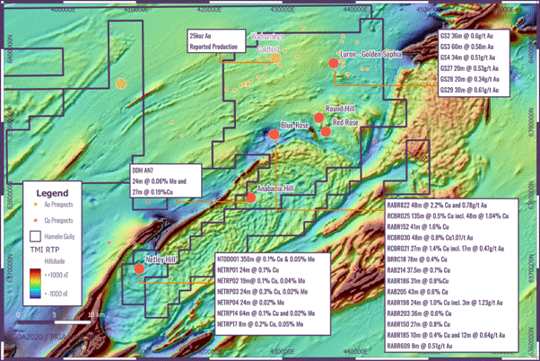
· Along-strike of the historic Wadnaminga goldfields where artisanal mining produced over 25,000 Oz of gold
· Mineralisation proximal to a blind magnetic anomaly that may represent the porphyry source
Follow this link to watch a short video of CEO Rupert Verco explaining the transaction and the Manna Hill Project: https://investors.cobraplc.com/link/rLwO0e
The Company will host a live Webinar on 3 September. Registration details will be provided in due course via RNS Reach.
Background to the Manna Hill Project
The Nakara Arc, a Cambrian age rift system, has long been recognised for its prospective porphyry systems. Previous work undertaken by the Geological Survey of South Australia, academics and explorers demonstrates:
· Deep crustal architecture defined within a Geoscience South Australia Magnetotelluric survey that defines modelled fertile, middle crust magma and structurally controlled conduits supportive of porphyry intrusions1
· Geochemical and geochronological studies performed by Hong et al, 2023, demonstrate that porphyritic stocks at Anabama and Netley Hill have formed from favourable lithospheric scale structures and simultaneously with known porphyry systems within the Macquarie Arc such as Cadia and North Parkes1
The project comprises numerous prospects with varying styles of mineralisation including skarn, porphyry, carlin, orogenic and sediment hosted mineralisation across 1,855 km2 of tenure that includes the historic Wadnaminga and Talkaboolka goldfields.
Exploration over the project has been limited over the last two decades owing to land access. Land access has been achieved with a Native Title Mining Agreement with the Wilyakali Traditional Owners paving the way for exploration across this highly fertile geological province.
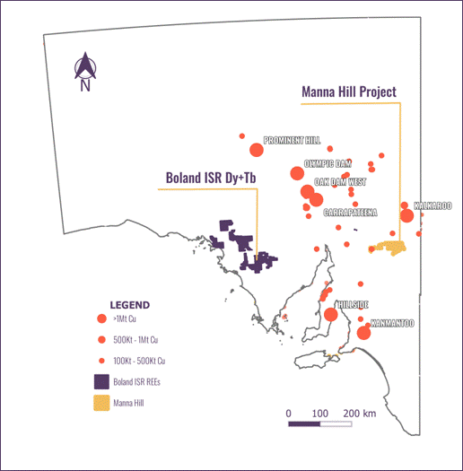
Located 150km south-west of Broken Hill, the township and mining asset that was the starting point for the world's largest miner, BHP, the region is well serviced by road and rail.
Figure 1: Location of the Manna Hill Project, South Australia and reported copper resources
In the south of the tenements, magnetics define the Anabama Granite intrusion, where a number of bullseye magnetic features occur in its proximity, previous exploration and academic studies have confirmed the presence of porphyry type Cu-Au-Mo mineralisation.
Figure 2: Total Magnetic Intensity, defining the emplacement of the Anabama Granite, the land tenure and the position of Porphyry and Orogenic gold prospects
Exploration Strategy During the Option Period
During the Option Period, Cobra aims to demonstrate the value of Manna Hill Project to its shareholders by focusing on the Blue Rose prospect, where a targeted drill programme will aim to add scale to the existing 1.6km of drilled mineralisation. The Company has refined the geological interpretation which supports scalable upside to existing, shallow skarn mineralisation.
Initial due diligence performed by Cobra's technical team has focussed on structural control of skarn copper-gold mineralisation at the Blue Rose Prospect where:
· Mineralisation is hosted within the footwall of a stratigraphically bound limestone unit where it intersects a large remanet de-magnetised low associated with an expected porphyry intrusion
· A single diamond hole targeting the porphyry intrusion intersected multiple quartz monzonite dykes and strong phyllic alteration - spectral analysis suggests close proximity to porphyry mineralisation
· Drilling has defined shallow copper-gold skarn mineralisation across 1.6km of strike east of the intrusion with intersections including:
o [RABR822] 47m at 2.2% Cu and 0.76 g.t Au from 11m
o [RCBR025] 132m at 0.52% Cu from 8m including 48m at 1.04% Cu
o [RABR152] 41m at 1.6% Cu from 9m including 18m at 2.03% Cu
o [RABR205] 43m at 0.6% Cu from 12m
o [RABR030] 57m at 0.77% Cu and 0.94 g/t Au from 80m
o [RCBR022] 80m @ 0.27% Cu incl. 15m @ 0.71% Cu, 0.17 g/t Au (1m @ 2450 ppm Mo)
o [RCBR030]: 16m @ 1.54% Cu, 0.78 g/t Au from 88m and 28m @ 1.29 g/t Au, 0.42% Cu from 104m2
o [RCBR021]: 27m @ 1.41% Cu, 0.33 g/t Au
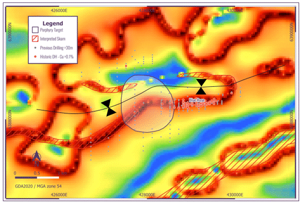
Figure 3: Previous exploration at the Blue Rose Skarn, significant intersections and grade shells over gravity
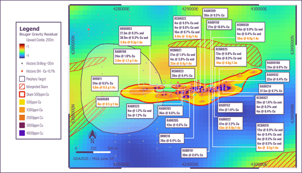
Figure 4: Cross Section 429325mE Blue Rose Skarn Mineralisation - highlighting the mineralised footwall of the limestone unit bound by carbonaceous shales
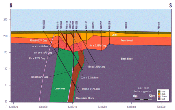
· Before the formation of the Nackara Arc, Adelaidean sediments were highly deformed during the Delamerian Orogeny resulting in folding of sedimentary sequences
· Re-processing of geophysical data highlights that the limestone unit hosting skarn mineralisation is folded (syncline), highlighting the further potential to host mineralisation within the fold hinge (at depth), within the northern limb and as continuities to the west of the porphyry intrusion
Figure 5: Gravity "edge" imagery where heat colours highlight the contrast within specific gravity. The zones of high contrast are interpreted to represent the limestone unit that hosts skarn mineralisation. Areas shaded in red are target zones that will be tested for continuity and scale
A heritage clearance is in place to enable a drill programme testing Blue Rose Skarn mineralisation. Cobra will confirm the integrity of historical drilling whilst testing the developed model for further scale by drilling:
o Zones of required infill to support a mineral resource estimate (MRE)
o The northern syncline limb
o Western extensions
o A higher-grade hinge zone at depth where fracturing and jointing generally may improve fluid migration, resulting in high concentrations of metal
Further geophysical inversion modelling is currently underway to define the depth of the fold hinge. Applications are being prepared to expediate this drilling programme.
Terms of the Option Deed
Parties
· Buyer: Manna Hill Mining Pty Ltd (wholly owned subsidiary of Cobra)
· Seller: TC Development Corporation Pty Ltd as trustee for The Springton Trust (David Clarke, a Cobra director, is a beneficiary of the Springton Trust "Springton")
· Licence Co.: Hamelin Gully Pty Ltd (holder of the Manna Hill Project licences)
Grant of Option
· Seller grants Buyer an exclusive option to acquire 100% of the share capital of the Licence Co. (the "Option Shares")
· Option Period: 12 months from commencement date
· Buyer may withdraw prior to exercising the Option with no liability
Purchase Price (upon exercise of Option)
· Contingent upon Cobra obtaining shareholder approval via a general meeting and subject to Rule 9 takeover provisions, the consideration for the Option shall be as follows:
o A$1,000,000 in Cobra shares (priced at 10-day VWAP before completion)
o Reimbursement of Seller's substantiated project expenditure (cash)
o 26% equity interest in any future mining SPV established to hold mining licences where the valuation is determined through two independent valuations
o Put and call option for Cobra to acquire Springton at the average of two independent valuations after 8 years from completion
Royalty
· Seller retains a 1% overriding royalty on production (per separate Royalty Deed)
Obligations During Option Period
· Seller must maintain licences in good standing and not dispose of assets
· Buyer has the exclusive right to explore at its own cost, with authority to act as the Licence Co.'s agent for land access and regulatory compliance
· Reporting obligations require Seller/Licence Co. to share all material information with Buyer
Completion
· Occurs within 5 business days of exercise of the Option
· Buyer issues Cobra shares, pays the reimbursement amount, and assumes control of Licence Co.
· Seller delivers corporate records, resignations of directors, and evidence of expenditure
Mining SPV & Future Structure
· If Cobra declares a JORC resource and is granted mining licences:
o Mining SPV ownership: 74% Buyer / 26% Seller
o Put and Call options allow either party to require sale of the 26% at a value determined by independent valuation
o Consideration may be paid in Cobra or SPV shares
Regulatory Compliance
· Completion maybe subject to rules of the London Stock Exchange and Australian Foreign Investment Review Board (FIRB) approvals if required
Warranties
· Standard mutual warranties on power and authority
· Seller warrants clear title to shares, licences, and all mining information
Termination & Withdrawal
· Option lapses if not exercised within Option Period
· Buyer may withdraw at any time before exercise without liability
· Termination requires return of confidential information and withdrawal of personnel
Disclaimers
Copper equivalent estimates presented in Figure 4 do not contain metallurgical recoveries and are therefore not a true reflection of economics - they have been used to simplify the presentation of down hole intersections. The formula for calculating the intersections is: CuEq% = Cu% + ((Au (g/t) x (US$3,000/31.10348) / (US$9,000/100)) + ((Mo % x (US$40,000/100) / ($9,000/100))
References
1. Wei Hong, Adrian Fabris, Tom Wise, Allan S Collins, Sarah Gilbert, David Selby, Stacey Curtis and Anthony Reid, 2023 Economic Geology. "Metallogenic Setting and Temporal Evolution of Porphyry Cu-Mo Mineralisation and Alteration in the Delamerian Orogen, South Australia: Insights From Zircon, U-Pb, Molybdenite Re-Os, and In Situ White Mica Rb-Sr Geochronology."
2. Collar coordinates for RCBR030 has not been verified within the database but was announced on 8 July 2002: asx.com.au/asx/v2/statistics/displayAnnouncement.do?display=text&issuerId=558&announcementId=493738&documentDate=2002-07-08&documentNumber=219186
The Boland Project
Cobra's unique and highly scalable Boland discovery is a strategically advantageous ionic rare earth discovery where high grades of valuable heavy and magnet rare earths occur concentrated in a permeable horizon confined by impermeable clays. Bench scale ISR testing has confirmed that mineralisation is amenable to ISR mining. ISR has been used successfully for decades within geologically similar systems to recover uranium within South Australia. Results of this metallurgical test work support that, with minor optimisation, ISR techniques should enable non-invasive and low-cost production of critical REEs from Cobra's Boland discovery.
The Manna Hill Project
Cobra has entered a binding Option Deed to acquire the Manna Hill Project, a forgotten porphyry province within the copper capital of Australia. The project has the potential to deliver the next tier 1 discovery. Historical intersections include 48m @ 2.2% Cu & 0.76 g/t Au and 132m at 0.5% Cu, underpin the potential to deliver the next multi-million tonne copper resource.
Further information relating to Cobra's Boland Project is presented in the appendices.
Enquiries:
| Cobra Resources plc Rupert Verco (Australia) Dan Maling (UK)
| via Vigo Consulting +44 (0)20 7390 0234
|
| SI Capital Limited (Joint Broker) Nick Emerson Sam Lomanto
| +44 (0)1483 413 500
|
| Global Investment Strategy (Joint Broker) James Sheehan | +44 (0)20 7048 9437 james.sheehan@gisukltd.com |
| Vigo Consulting (Financial Public Relations) Ben Simons Kendall Hill | +44 (0)20 7390 0234 cobra@vigoconsulting.com |
The person who arranged for the release of this announcement was Rupert Verco, Managing Director of the Company.
Competent Persons Statement
Information and data presented within this announcement has been compiled by Mr Robert Blythman, a Member of the Australian Institute of Geoscientists ("MAIG"). Mr Blythman is a Consultant to Cobra Resources Plc and has sufficient experience, which is relevant to the style of mineralisation, deposit type and to the activity which he is undertaking to qualify as a Competent Person defined by the 2012 Edition of the Australasian Code for Reporting Exploration Results, Mineral Resources and Ore Reserves (the "JORC" Code). This includes 12 years of Mining, Resource Estimation and Exploration relevant to the style of mineralisation.
Information in this announcement has been assessed by Mr Rupert Verco, a Fellow of the Australasian Institute of Mining and Metallurgy. Mr Verco is an employee of Cobra and has more than 17 years' industry experience which is relevant to the style of mineralisation, deposit type, and activity which he is undertaking to qualify as a Competent Person as defined in the 2012 Edition of the Australasian Code for Reporting Exploration Results, Mineral Resources and Ore Reserves of JORC. This includes 13 years of Mining, Resource Estimation and Exploration.
About Cobra
In 2023, Cobra discovered a rare earth deposit with the potential to re-define the cost of rare earth production. The highly scalable Boland ionic rare earth discovery at Cobra's Wudinna Project in South Australia's Gawler Craton is Australia's only rare earth project amenable for in situ recovery (ISR) mining - a low cost, low disturbance method enabling bottom quartile recovery costs without any need for excavation or ground disturbance. Cobra is focused on de-risking the investment value of the discovery by proving ISR as the preferred mining method and testing the scale of the mineralisation footprint through drilling.
Cobra's Wudinna tenements also contain extensive orogenic gold mineralisation, including a 279,000 Oz gold JORC Mineral Resource Estimate, characterised by low levels of over-burden, amenable to open pit mining.
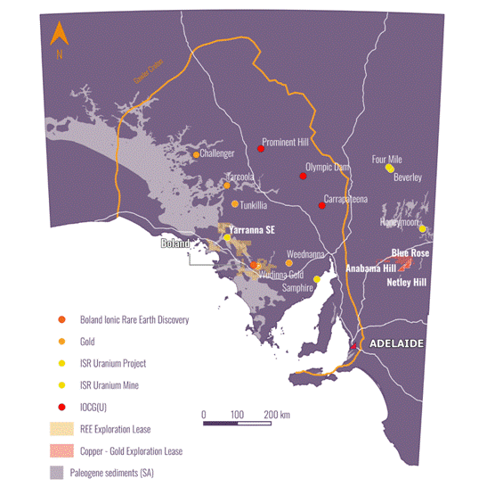
Regional map showing Cobra's projects - The Boland Rare Earth Project & The Manna Hill Copper Project
Follow us on social media:
LinkedIn: https://www.linkedin.com/company/cobraresourcesplc
X: https://twitter.com/Cobra_Resources
Engage with us by asking questions, watching video summaries and seeing what other shareholders have to say. Navigate to our Interactive Investor hub here: https://investors.cobraplc.com/
Subscribe to our news alert service: https://investors.cobraplc.com/auth/signup
Appendix 1: Background information - the Boland Project and ISR
· The Boland Project was discovered by Cobra in 2023. Mineralisation is ionically bound to clays and organics within palaeochannel sands within the Narlaby Palaeochannel
· Mineralisation occurs within a permeable sand within an aquifer that is saltier than sea water and is confined by impermeable clays
· ISR is executed through engineered drillhole arrays that allow the injection of mildly acidic ammonium or magnesium sulphate lixiviants, using the confining nature of the geology to direct and lower the acidity of the orebody. This low-cost process enables mines to operate profitably at lower grades and lower rates of recovery
· Once REEs are mobile in solution in groundwater, it is also possible, from an engineering standpoint, to recover the solution to surface via extraction drillholes, without any need for excavation or ground disturbance
· The capital costs of ISR mining are low as they involve no material movements and do not require traditional infrastructure to process ore - i.e. metals are recovered in solution
· Ionic mineralisation is highly desirable owing to its high weighting of valuable HREOs and the cost-effective method in which REEs can be desorbed
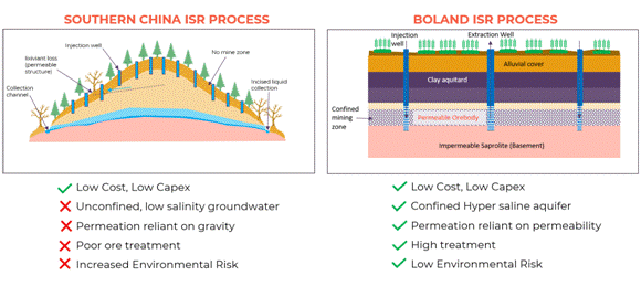
· Ionic REE mineralisation in China is mined in an in-situ manner that relies on gravity to permeate mineralisation. The style of ISR process is unconfined and cannot be controlled, increasing the risk for environmental degradation. This low-cost process has enabled China to dominate mine supply of HREOs, supplying over 90% globally
· Confined aquifer ISR is successfully executed globally within the uranium industry, accounting for more than 60% of the world's uranium production. This style of ISR has temporary ground disturbance, and the ground waters are regenerated over time
· Cobra is aiming to demonstrate the economic and environmental benefits of recovering ionic HREOs through the more environmentally aquifer controlled ISR - a world first for rare earths
Figure A1: Comparison between the Chinese and the proposed Boland process for ISR mining of REEs
Appendix 2: JORC Code, 2012 Edition - Table 3
| Criteria | JORC Code explanation | Commentary |
| Sampling techniques | · Nature and quality of sampling (eg cut channels, random chips, or specific specialised industry standard measurement tools appropriate to the minerals under investigation, such as down hole gamma sondes, or handheld XRF instruments, etc). These examples should not be taken as limiting the broad meaning of sampling. · Include reference to measures taken to ensure sample representivity and the appropriate calibration of any measurement tools or systems used. · Aspects of the determination of mineralisation that are Material to the Public Report. · In cases where 'industry standard' work has been done this would be relatively simple (eg 'reverse circulation drilling was used to obtain 1 m samples from which 3 kg was pulverised to produce a 30 g charge for fire assay'). In other cases more explanation may be required, such as where there is coarse gold that has inherent sampling problems. Unusual commodities or mineralisation types (eg submarine nodules) may warrant disclosure of detailed information. | · Drill results are historic, reported from previous explorers across multiple company databases. · GS Series holes have uncertain sampling methods but 2024 HGRC series holes across reflected the grade tenor and distribution · Blue Rose drill results were undertaken over multiple generations with validation required. Sample lengths were between 1m and 4m. sample types are listed as composites and splits in historically reported data for the reported results. · NETRP series holes were completed in the late 1960s as percussion holes. Results are considered reflective of typical grades and scale but are historic in nature. · NETDD holes were diamond holes that were half core samples to 1m length. · Select review of sampling data provided indicates the retained data is of good quality. |
| Drilling techniques | · Drill type (eg core, reverse circulation, open-hole hammer, rotary air blast, auger, Bangka, sonic, etc) and details (eg core diameter, triple or standard tube, depth of diamond tails, face-sampling bit or other type, whether core is oriented and if so, by what method, etc). | RAB, AC, RC, percussion and diamond drilling methods have all been used with AC and RC being the dominant drill methods on a per m basis. Further assessment of the drilling methods will be undertaken during data validation and migration. Select review of drilling data provides indicates the retained data is of good quality. |
| Drill sample recovery | · Method of recording and assessing core and chip sample recoveries and results assessed. · Measures taken to maximise sample recovery and ensure representative nature of the samples. · Whether a relationship exists between sample recovery and grade and whether sample bias may have occurred due to preferential loss/gain of fine/coarse material. | · Sample recovery data is limited. · Blue Rose prospect, sample codes L.N.R. are less than 0.1% of assessed data. · Netley Hill, Diamond drilling appears to have excellent recoveries based on core photos with NTRP sewries holes not expected to have recovery data · At Golden Sophia, 2024 HGRC drilling had consistent good recoveries as reported in sampling with historic GS drilling expected to be comparable. |
| Logging | · Whether core and chip samples have been geologically and geotechnically logged to a level of detail to support appropriate Mineral Resource estimation, mining studies and metallurgical studies. · Whether logging is qualitative or quantitative in nature. Core (or costean, channel, etc) photography. · The total length and percentage of the relevant intersections logged. | · A review of historic logging has determined the quality of logging to be good. · Translation of logging codes to a uniform code library across the project will be undertaken to ensure consistency of historic logging for future interpretation. |
| Sub-sampling techniques and sample preparation | · If core, whether cut or sawn and whether quarter, half or all core taken. · If non-core, whether riffled, tube sampled, rotary split, etc and whether sampled wet or dry. · For all sample types, the nature, quality and appropriateness of the sample preparation technique. · Quality control procedures adopted for all sub-sampling stages to maximise representivity of samples. · Measures taken to ensure that the sampling is representative of the in situ material collected, including for instance results for field duplicate/second-half sampling. · Whether sample sizes are appropriate to the grain size of the material being sampled. | · Sample data is historic and all processes and proceduresare unknown. There is records of sample splits being sent for lab analysis after initial composite sampling had taken place. Core samples are reported to be half core sent to the lab · Further validation of the data will be undertaken during the data validation and migration. · Sampling technique is not expected to have applied a bias to results.
|
| Quality of assay data and laboratory tests | · The nature, quality and appropriateness of the assaying and laboratory procedures used and whether the technique is considered partial or total. · For geophysical tools, spectrometers, handheld XRF instruments, etc, the parameters used in determining the analysis including instrument make and model, reading times, calibrations factors applied and their derivation, etc. · Nature of quality control procedures adopted (eg standards, blanks, duplicates, external laboratory checks) and whether acceptable levels of accuracy (ie lack of bias) and precision have been established. | · Laboratory analysis is from cetified labs and most certificates are on file therefore analysis is expected to be of adequate quality · NETRP series holes have limited associated lab data but are considered to be refective of in situ grades and acceptable to report in a historic context. · Historic lab certificates indicate analytical methods have been primarily 4 acid digest for ore grade copper and a mixture of aqua regia and fire assay for gold. Other elements assayed have been a mixture of aqua regia digest and 4 acid digest. These techniques are acceptable in this geological setting with 4 acid digest preferred. · Standards, blanks and duplicates have been included in some historic lab jsubmissions. |
| Verification of sampling and assaying | · The verification of significant intersections by either independent or alternative company personnel. · The use of twinned holes. · Documentation of primary data, data entry procedures, data verification, data storage (physical and electronic) protocols. · Discuss any adjustment to assay data. | · Historic data has been compiled from multiple open file and historic company sources · For Blue Rose, drill results are geologically consistent across multiple historic drill programs managed by different companies and different drill techniques · For Netley Hill, NETRP holes are considered historic and indicative, NETDD holes are considered to be of high quality. · Data validation will be completed on compiled data during a database migration to ensure appropriate confidence in results is applied. · Historic lab certificate results will be used as a primary source for a large portion of assay data · Significant intersections have been prepared by Mr Robert Blythman and reviewed by Mr Rupert Verco |
| Location of data points | · Accuracy and quality of surveys used to locate drill holes (collar and down-hole surveys), trenches, mine workings and other locations used in Mineral Resource estimation. · Specification of the grid system used. · Quality and adequacy of topographic control. | · Drillhole collars have been picked up by GPS post 2003 based on historic reporting · Prior to 2003, drillholes were reported as NOM · Field validation of historic collars shows historic holes were within 10-20m consistently and generally within 5m · NETRP series holes have not been field validated and are considered spatially indicative. Limited historical surface evidence indicates the program occurring in the correct area. |
| Data spacing and distribution | · Data spacing for reporting of Exploration Results. · Whether the data spacing and distribution is sufficient to establish the degree of geological and grade continuity appropriate for the Mineral Resource and Ore Reserve estimation procedure(s) and classifications applied. · Whether sample compositing has been applied. | · All reported results are being reported as historic in nature with no resource classification applied at this stage. · Preliminary review of the historic data available has the potential to be used in a resource estimation, particularly at Blue Rose once historic data validation has been completed. · Significant intersections have been calculated as downhole length weighted averages. |
| Orientation of data in relation to geological structure | · Whether the orientation of sampling achieves unbiased sampling of possible structures and the extent to which this is known, considering the deposit type. · If the relationship between the drilling orientation and the orientation of key mineralised structures is considered to have introduced a sampling bias, this should be assessed and reported if material. | · Intersections are expected to be oblique to mineralization. · Drill orientation is not expected to have introduced bias to grades reported |
| Sample security | · The measures taken to ensure sample security. | · Samples are considered historic, no tampering with samples is expected. · HGRC series drillholes were zip tied in polyweave bags and sent directly to the lab by Hamelin Gully contractors from the drill site in zip tied Bulka bags. |
| Audits or reviews | · The results of any audits or reviews of sampling techniques and data. | · A full review of historic data is underway to ascertain historic data confidence. Preliminary findings have shown drilling and assay data is of a good quality and appropriate for further use. |
Appendix 3: Section 2 reporting of exploration results
| Criteria | JORC Code explanation | Commentary |
| Mineral tenement and land tenure status | · Type, reference name/number, location and ownership including agreements or material issues with third parties such as joint ventures, partnerships, overriding royalties, native title interests, historical sites, wilderness or national park and environmental settings. · The security of the tenure held at the time of reporting along with any known impediments to obtaining a licence to operate in the area. | · EL's 6009, 6046 and 6646 are 100% Owned by Hamelin Gully Pty Ltd and are in good standing · A Native Title Mining Access Agreement is in Place between Hamelin Gully and the Wilyakali Traditional Owners. A 1% over riding royalty is in place between Hamelin Gully and David Clarke, · |
| Exploration done by other parties | · Acknowledgment and appraisal of exploration by other parties. | · A multitude of historic explorers have undertaken exploration over the area. · PacMag, Giralia, Lynas, Dominion, Panda and Hamelin Gully have completed a number of geophysical, surface and drillhole exploration programs across the tenement package. The tenement package has also had government exploration undertaken over the Netley Hill, Anabama Hill and Blue Rose Project areas. Exploration has primarily been focused on porphyry- skarn copper and gold mineralization. Iron ore exploration has been undertaken on the periphery of the exploration package |
| Geology | · Deposit type, geological setting and style of mineralisation. | · Mineralisation is associated with the Anabama Granite and adjacent Adelaidean metasediments within the Nackara Arc of the Delamerian Orogen. · Deposit styles include: · Porphyry Cu-Mo systems with greisen overprint hosted within the granite. · Skarn and replacement (manto-style) Cu-Au mineralisation developed in carbonate metasediments proximal to intrusive contacts. · Structurally controlled quartz-reef/orogenic gold styles within folded Adelaidean sequences, analogous to the Manna Hill goldfield. · Geological setting is characterised by early Palaeozoic granite intrusion into Adelaidean platform sediments, with contact-related alteration and deformation associated with the Delamerian Orogeny. · Styles of mineralisation include disseminated and stockwork sulphides (chalcopyrite, pyrite, molybdenite), carbonate replacement/recrystallisation with sulphides, and quartz-sulphide reef systems in shear/fold settings
|
| Drillhole Information | · A summary of all information material to the understanding of the exploration results including a tabulation of the following information for all Material drill holes: o easting and northing of the drill hole collar o elevation or RL (Reduced Level - elevation above sea level in metres) of the drill hole collar o dip and azimuth of the hole o down hole length and interception depth o hole length. · If the exclusion of this information is justified on the basis that the information is not Material and this exclusion does not detract from the understanding of the report, the Competent Person should clearly explain why this is the case. | · see appendix 3 · A full review and validation of all historic data is currently being undertaken prior to the full report of all historic data. |
| Data aggregation methods | · In reporting Exploration Results, weighting averaging techniques, maximum and/or minimum grade truncations (eg cutting of high grades) and cut-off grades are usually Material and should be stated. · Where aggregate intercepts incorporate short lengths of high grade results and longer lengths of low grade results, the procedure used for such aggregation should be stated and some typical examples of such aggregations should be shown in detail. · The assumptions used for any reporting of metal equivalent values should be clearly stated. | · Significant intersections are calculated as length weighted averages. · Only metal equivalent values were applied within the cross section (Figure 4) to simplify overlapping intersections. The formula applied does not include metal recoveries and is therefore not a true representation of mineral economics. Applied formula is: · CuEq% = Cu% + ((Au (g/t) x (US$3,000/31.10348) / (US$9,000/100)) + ((Mo % x (US$40,000/100) / ($9,000/100)) |
| Relationship between mineralisation widths and intercept lengths | · These relationships are particularly important in the reporting of Exploration Results. · If the geometry of the mineralisation with respect to the drill hole angle is known, its nature should be reported. · If it is not known and only the down hole lengths are reported, there should be a clear statement to this effect (eg 'down hole length, true width not known'). | · Intercept lengths are oblique to mineralization with downhole lengths reported only · Further review of historic data is required before determining true drillhole width |
| Diagrams | · Appropriate maps and sections (with scales) and tabulations of intercepts should be included for any significant discovery being reported These should include, but not be limited to a plan view of drill hole collar locations and appropriate sectional views. | · Relevant diagrams have been included in the announcement. · Exploration results are not being reported for existing mineral resources. · Additional collar locations in diagrams reflect spatial location of historic data under review. |
| Balanced reporting | · Where comprehensive reporting of all Exploration Results is not practicable, representative reporting of both low and high grades and/or widths should be practiced to avoid misleading reporting of Exploration Results. | · Significant intersections have been reported to highlight exploration potential of the project. Upon completion of historic data review, further reporting of existing results will be reported |
| Other substantive exploration data | · Other exploration data, if meaningful and material, should be reported including (but not limited to): geological observations; geophysical survey results; geochemical survey results; bulk samples - size and method of treatment; metallurgical test results; bulk density, groundwater, geotechnical and rock characteristics; potential deleterious or contaminating substances. | · Completion of historic exploration data is underway. All meaningful results will be released once the historic data review has been completed. |
| Further work | · The nature and scale of planned further work (eg tests for lateral extensions or depth extensions or large-scale step-out drilling). · Diagrams clearly highlighting the areas of possible extensions, including the main geological interpretations and future drilling areas, provided this information is not commercially sensitive. | · Finalisation of historic data review. · Planning for RC and diamond drilling at Blue Rose and Netley Hill Prospects underway; Drilling will aim to confirm geological interpretations and validate pervious intersections |
Appendix 3. Collar locations of reported intersections
| BHID | Easting | Northing | Elevation | Dip | Azimuth | Length |
| BRDD003 | 429020 | 6388425 | 240 | -60.8 | 172 | 227.8 |
| BRRB11 | 428922 | 6388377 | 239 | -90 | 0 | 48 |
| BRRC18 | 429052 | 6388338 | 238 | -90 | 0 | 100 |
| GS2 | 437060 | 6398114 | 287 | -60 | 340 | 40 |
| GS27 | 437151 | 6398102 | 285 | -60 | 162 | 40 |
| GS29 | 437160 | 6398064 | 285 | -60 | 162 | 40 |
| GS3 | 437067 | 6398084 | 287 | -60 | 344 | 70 |
| GS4 | 437075 | 6398046 | 286 | -60 | 343 | 40 |
| HGRC0003 | 437090 | 6398076 | 286 | -60 | 345 | 124 |
| NTDD001 | 411017 | 6370179 | 280 | -90 | 0 | 350 |
| NETRP14 | 410433 | 6370263 | 280 | -90 | 0 | 76 |
| NETRP03 | 411053 | 6370125 | 280 | -90 | 0 | 79 |
| RABR186 | 429372 | 6388377 | 235 | -90 | 0 | 40 |
| RABR150 | 429272 | 6388357 | 237 | -90 | 0 | 47 |
| RABR151 | 429322 | 6388382 | 236 | -90 | 0 | 60 |
| RABR152 | 429372 | 6388357 | 236 | -90 | 0 | 50 |
| RABR155 | 429372 | 6388347 | 236 | -60 | 172 | 23.5 |
| RABR187 | 429372 | 6388297 | 237 | -90 | 0 | 40 |
| RABR191 | 429272 | 6388337 | 237 | -90 | 0 | 37 |
| RABR198 | 428822 | 6388403 | 239 | -90 | 0 | 54 |
| RABR203 | 428922 | 6388327 | 238 | -90 | 0 | 51 |
| RABR205 | 429022 | 6388352 | 239 | -90 | 0 | 55 |
| RABR209 | 429172 | 6388327 | 237 | -90 | 0 | 59 |
| RABR211 | 429321 | 6388278 | 237 | -90 | 0 | 19 |
| RABR212 | 429322 | 6388252 | 237 | -90 | 0 | 63 |
| RABR213 | 429322 | 6388227 | 236 | -90 | 0 | 42 |
| RABR214 | 429472 | 6388402 | 232 | -90 | 0 | 46.5 |
| RABR523 | 428872 | 6388327 | 238 | -90 | 0 | 72 |
| RABR609 | 428722 | 6388302 | 240 | -90 | 0 | 54 |
| RABR822 | 429348 | 6388361 | 236 | -90 | 0 | 59 |
| RBBR18 | 429322 | 6388177 | 235 | -90 | 0 | 12 |
| RCBR019 | 429322 | 6388337 | 237 | -90 | 0 | 122 |
| RCBR021 | 429127 | 6388342 | 238 | -90 | 0 | 152 |
| RCBR022 | 429122 | 6388377 | 238 | -60 | 172 | 122 |
| RCBR023 | 429122 | 6388327 | 238 | -60 | 172 | 116 |
| RCBR025 | 429322 | 6388377 | 236 | -60 | 172 | 140 |
| RCBR026 | 429322 | 6388327 | 237 | -60 | 172 | 116 |
| RCBR027 | 429422 | 6388352 | 234 | -60 | 172 | 110 |
| RCBR029D | 429322 | 6388427 | 236 | -60 | 172 | 219 |
| RCBR030 | 429122 | 6388427 | 238 | -60 | 172 | 188 |
RNS may use your IP address to confirm compliance with the terms and conditions, to analyse how you engage with the information contained in this communication, and to share such analysis on an anonymised basis with others as part of our commercial services. For further information about how RNS and the London Stock Exchange use the personal data you provide us, please see our Privacy Policy.